
Climbing Mount Snowdon

The first thing we did the day after arriving in Snowdonia was walk up to the top of Mount Snowdon. It is 1085 metres high, and the highest mountain in England and Wales. A bit of research beforehand revealed that there are 8 main routes to the top, ranked from hardest to easiest these are:
- Crib Goch – lots of scrambling and exposure on the ridge lines. Easier to lose the path and scramble where one shouldn’t be scrambling.
- Watkin path – the one we did. More direct ascent and involves a lot of scrambling over rocks and scree in the second half of the walk. A path is currently being built on the second half so I expect the scree slope parts to become a lot easier once it’s complete.
- Snowdon South Ridge – a bit longer than the routes below, some scrambling and over Bwlch Main.
- Pyg track – the terrain is much rougher and harder to traverse.
- Rhyd Ddu Path – similar to miners track, but has a difficult section over Bwlch Main.
- Miners track – easy for the first half, then scrabbling the second half.
- Ranger Path – easy for the first third then a bit of rock scrabbling in the middle.
- Llanberis Path – generally viewed as the most straight forward route up Snowdon. It’s a gradual ascent all the way, so if you dislike long walks it could be the hardest.
Bwlch Main is an exposed, narrow ridge line that elevates some of the routes to a harder ranking. It has steep slopes either side and can be daunting in bad weather, or windy conditions.
We parked right at the base of the mountain at Nant Gwynant, the main reason we chose Watkins path was because it was the closest to Blaenau Ffestiniog where we were staying. The walk starts with a meander through a beautiful bluebell wood.


It then cuts up into the valley and follows the river up towards the peak. This part of the walk is pretty easy as its along the old slate mining track to the quarry.

The hard bit of the walk starts after the quarry on the route. It starts to climb more steeply towards the first ridge on the route, once on the ridge its a brief walk over an exposed part where the wind is funneled between a lower gap between the mountains. It then turns into a steep scramble, negotiating scree slopes and climbing over rocks. The path is more hidden and it is easy to lose it amongst the scree.
")
")
")
You can see in the photos how the rain came in showers that swept over the mountain. We saw them gradually grow closer and then wash over us and carry onwards. It wasn’t heavy enough to soak us for long and thankfully some missed us completely.


There is a proper path for the final stretch to the top. The clouds occasionally cleared on the peak and we caught glimpses of the view through the clouds. There are a series of steps up to the trig point at the very top, littered with people in flip flops who caught the train up. I heard one such person say “take another one, it’s a bit blurry”. I didn’t point out that we’re standing in the middle of a cloud at the top of a mountain. We didn’t spend long in the cloud, instead deciding to descend a little way and have lunch with a view in a sheltered spot away from the crowds. The seagulls instantly spotted us and started to swoop down.

The first one quickly called his gang and we soon had four flying overhead attempting to land in the wind.

The weather started to clear after lunch and we had a sunny scramble back off the mountain.

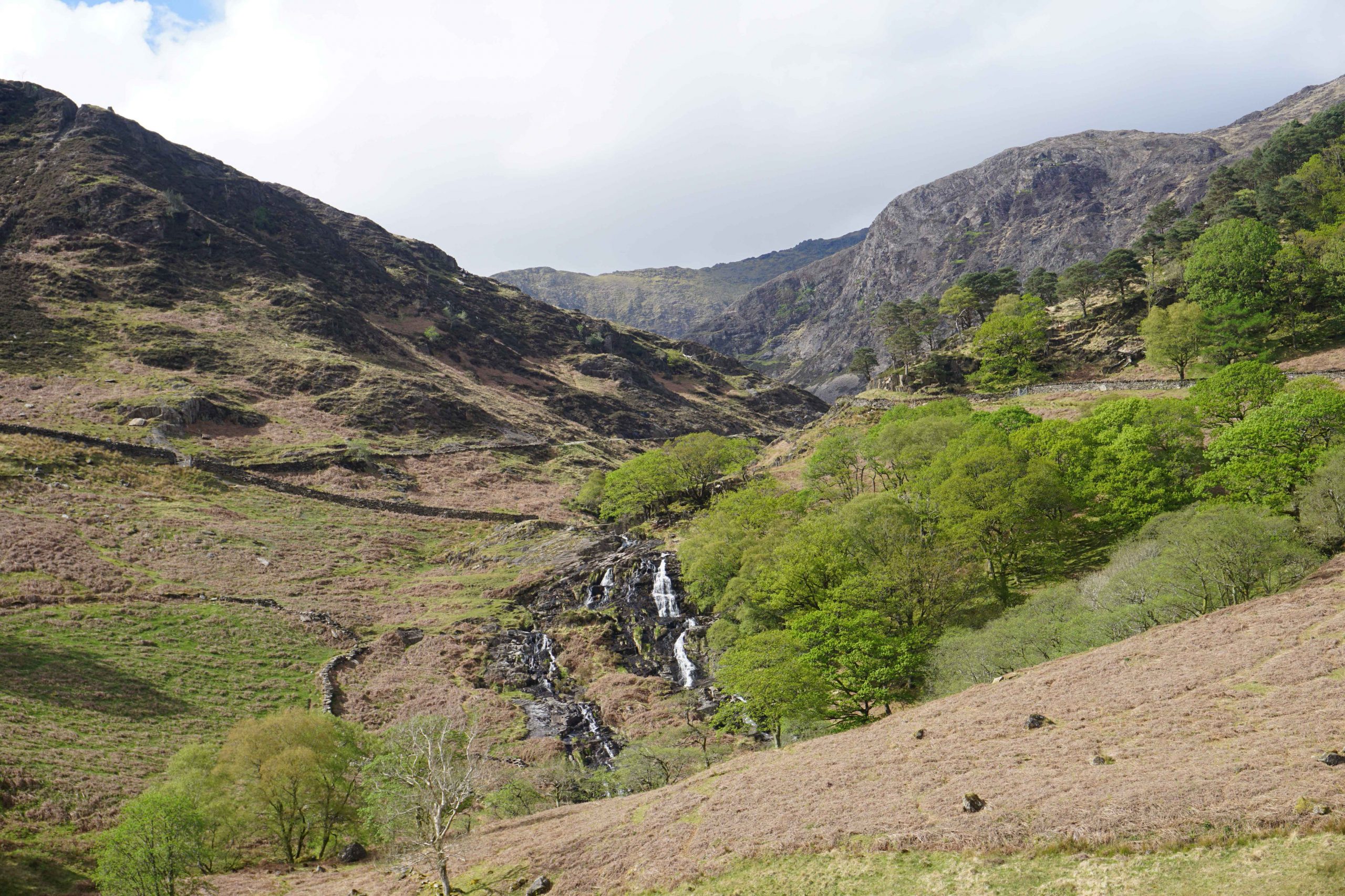
The glimpses of sun as it poked through the clouds was ideal for attempting longer shutter speed photos of the waterfall towards the bottom of the mountain. I managed to settle the camera enough to take a clear photo of the water.


The Three Peaks
Ben Nevis
Mount Snowdon
Scarell Pike – to do!

